ParkIt
This was a project undertaken in HCC8310 - Fundamentals of Human-Centered Computing, under Dr. Brygg Ullmer. I worked on this project with Deyrel Diaz, and our aim was to design an application that would assist students with their parking needs by first understanding the process from afar and then formulating a solution that would not only alleviate the issues but also prove to be a viable implementation.
Objective
Finding an optimal space for cars can be a challenging task. In spaces that experience daily traffic, managing the flow of vehicles to and from densely populated areas such as parking lots becomes extremely important to make sure that this flow does not disrupt external traffic. Our objective with ParkIt was to propose a system that utilizes the concept of spot-reservation and confirmation and conveys information intuitively, making use of visual representation.
Interdisciplinary Facets
Our proposed system aims to delve deeper into three major interdisciplinary domains to create a more viable, human-centered solution: Computer Science, Graphic Design, and Human Factors. Software is made by keeping people in mind; however, it ends up increasing the workload of its users by having them spend time understanding the product. Incorporating the computer science principles of graphic and visual design enables developers to make applications that are easy-to-understand, as well as easy-to-use.
Components
There are two primary components to this system; the mobile user interface, and the display and visualization boards.
Mobile UI
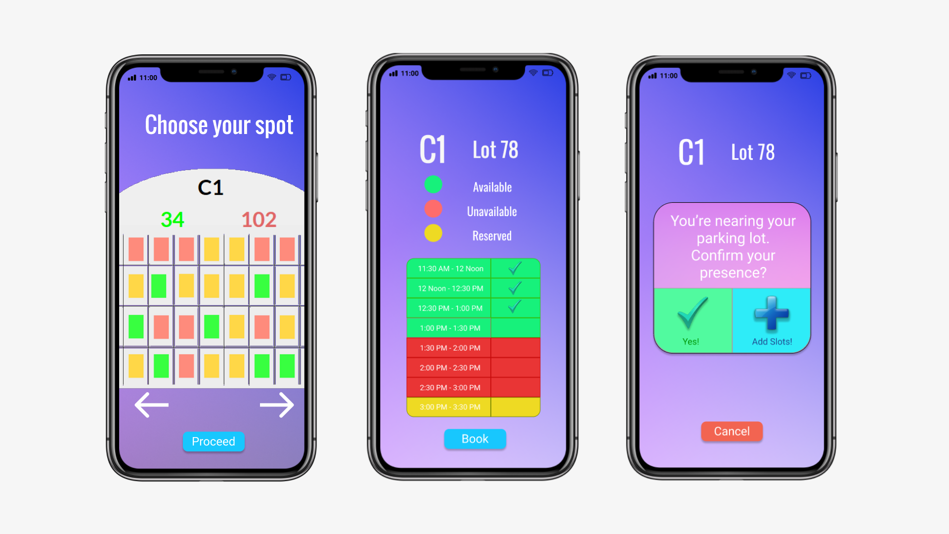
ParkIt was designed to employ Global Positioning System (GPS) sosftware to connect to a cloud-based network which would then directly interact with the display and visualization boards present throughout nearby parking lots. The mobile application lets students choose the parking spot they would like to park in.
The app could also recommend the most efficient spot based on the users' past behaviors to minimize the time it took for them to walk from their vehicles to the buildings where their classes were held, thereby maximizing efficiency.
Next, users would be given the choice of selecting the time slots in which they would be occupying their selected spot. Once they were done with the selection process, they could complete the procedure and reserve their parking spot. While they are driving towards the reserved spot, the application would calculate the users' position and alert the driver if they were detected to be within one mile of the parking lot. The users were required to confirm their presence after parking their vehicle, after which they would be allowed to be there for the duration of their reservation, or extend it until later if the need arose. This was done to prevent people from taking up spots that they would not be needing.
Visualization & Display Boards
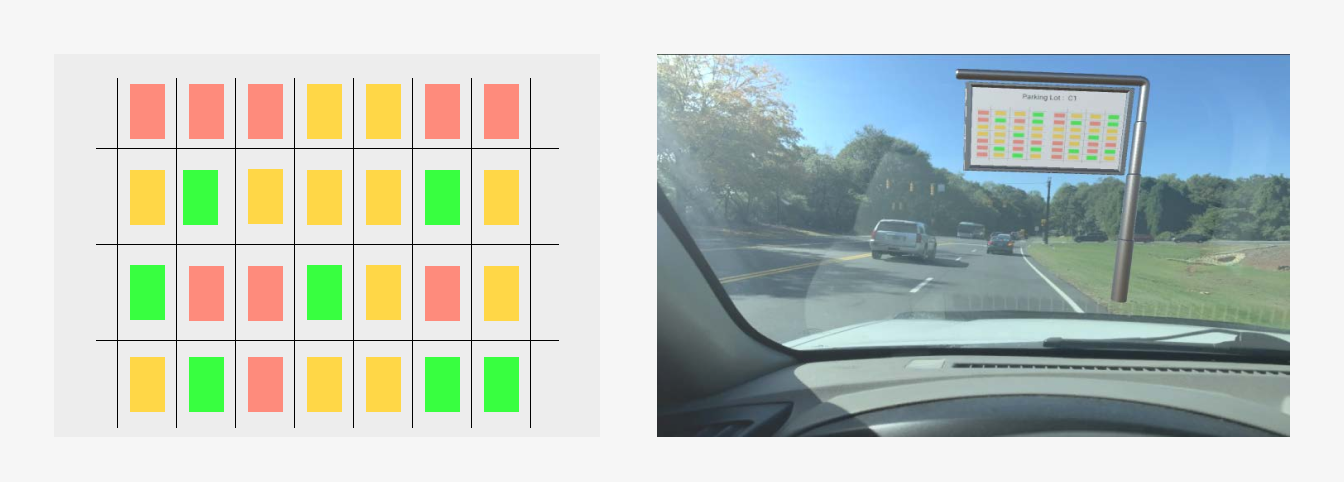
The Visualization Board (VBoard) helps with conveying useful information about nearby parking lots. The open space it would be installed in can improve optimality while still displaying relevant data. Since the VBoard does not take up space on the roads, drivers can use their time efficiently while sitting in traffic to decide whether they want to wait in line for the current parking lot or choose a different option.
The VBoard shows the parking lot in a grid-like format. It uses visual representations and colors to notify people whether particular spots are available or not. Each spot on the grid is mapped to a real-world parking spot. The VBoard will also cycle between other parking lots present nearby. The grid consists of three colors that represent the state of each parking spot at any given time. Green boxes are used to indicate available spots, meaning that those spots are open and can be used to park a vehicle. Yellow boxes represent spots that are open, but unavailable due to prior reservation. Red boxes show those spots that are unavailable due to prior reservation. Red boxes show those spots that are unavailable, being currently occupied by a vehicle. These colors have been chosen in order to ensure that the VBoard will disseminate critical information without requiring constant focus. These gradients can easily be picked up in the user's peripheral vision.

The Display Board (DBoard) works in tandem with the VBoard. It is located near the entrance of a each parking lot, and provides a way for users (who haven't done prior reservation) to reserve a spot. In such cases, the second step of location detection would not be needed, seeing as the vehicle is already present in the vicinity of the desired location. The second purpose that the DBoard serves is that of optional assistance. For people unfamiliar with the parking lot, it offers a choice for enabling guiding lights, which would then assign a random color and light the LEDs located on the side of the road to the designated spot.
Wireframes
Once we had an initial idea in mind about how we thought the application would function, it was time to implement those ideas visually via wireframes. We chose Figma for this project, since it was a high-fidelity and intuitive design tool that provided us with a wide variety of device types and device sizes. Since we intended for our system to be used on the go, we finalized on a mobile UI, and accordingly mapped out the corresponding user interface layout.

